Tour Scotland photographs and videos from my tours of Scotland. Photography and videography, both old and new, from beautiful Scotland, Scottish castles, seascapes, rivers, islands, landscapes, standing stones, lochs and glens.
Tour Scotland photograph of a box type farm cart at Fife Folk Museum, Ceres, Fife, Scotland. The un-sprung cart was a simple, sturdy, one horse, two wheeled vehicle used by roadmen, farmers and the like for small loads of relatively dense material like road metal or dung. In Australia and New Zealand, it is frequently called a dray. Elsewhere, that is a name occasionally used. The name dray is also used for a wagon. A sprung cart, by contrast was a light, one horse, or often, pony, two wheeled vehicle with road springs, for the carriage of passengers on informal occasions. It was a class of vehicles with the name varying according to the body mounted on it.
All photographs are copyright of Sandy Stevenson, Tour Scotland, and may not be used without permission.
June 26th photograph of The Provost in Ceres, Fife, Scotland. The Toby Jug statue of the Reverend Thomas Buchanan, Minister of Ceres from 1578 to 1599, known as "the Provost of Ceres." He was a man of great learning and a nephew of George Buchanan, the famous historian. He was minister of the village Kirk of Ceres and the last Provost of Ceres.
All photographs are copyright of Sandy Stevenson, Tour Scotland, and may not be used without permission.
June 26th photograph of the Maid Of The Tay boat on the River Tay in Perth, Perthshire, Scotland. The Maid Of The Tay has started running boat trips up the River Tay, from Newburgh in North Fife up to Perth. An excellent idea.
June 26th photograph of the Maid Of The Tay boat on the River Tay in Perth, Perthshire, Scotland.
June 26th photograph of the Maid Of The Tay boat on the River Tay in Perth, Perthshire, Scotland.
All photographs are copyright of Sandy Stevenson, Tour Scotland, and may not be used without permission.
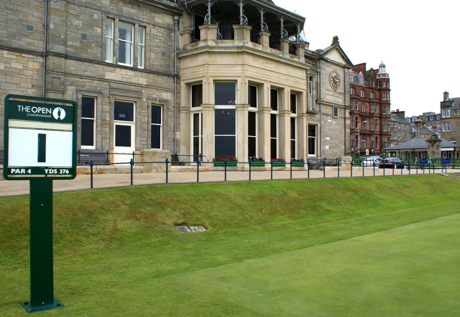
June 26th photograph of the 1st Tee at the Old Golf Course, St Andrews, Scotland. The imposing 1854 clubhouse overlooks the 1st and 18th holes of the Old Course and is the headquarters of the Royal and Ancient Golf Club. Golf Scotland.
All photographs are copyright of Sandy Stevenson, Tour Scotland, and may not be used without permission.
June 26th photograph of Balcarres Chapel, East Neuk of Fife, Scotland. Balcarres Chapel, in the east garden of Balcarres House, was built for David Lindsay, 1st Lord Balcarres in 1635.
All photographs are copyright of Sandy Stevenson, Tour Scotland, and may not be used without permission.
June 26th photograph of Lower Largo, East Neuk of Fife, Scotland. Had lunch today at the Crusoe Hotel in Lower Largo. Very warm and very overcast today.
All photographs are copyright of Sandy Stevenson, Tour Scotland, and may not be used without permission.
June 26th photograph of the City of St Andrews Pipe Band in Ceres, Fife, Scotland. This Scottish Pipe Band was performing today at the Ceres Highland Games.
June 26th photograph of the City of St Andrews Pipe Band in Ceres, Fife, Scotland.
June 26th photograph of the City of St Andrews Pipe Band in Ceres, Fife, Scotland.
All photographs are copyright of Sandy Stevenson, Tour Scotland, and may not be used without permission.
June 26th photograph of the Bannockburn Memorial in Ceres, Fife, Scotland. A modern memorial dedicated to the men from Ceres who fought in the Battle of Bannockburn.
All photographs are copyright of Sandy Stevenson, Tour Scotland, and may not be used without permission.
The Battle of Bannockburn, fought over two days on 23rd and 24th June in 1314 by a small river crossing in Stirling, was a decisive victory for Robert the Bruce in the Scottish Wars of Independence against the English. It was the greatest defeat the English would suffer throughout the Middle Ages, and a huge personal humiliation for King Edward II. Chris Brown's startling new history recreates the campaign and battle from the perspectives of both the Scots and English. Only now, through an in-depth investigation of the contemporary narrative sources as well as the administrative records, and through a new look at the terrain where the battle was fought, can we really begin to understand what exactly happened, and why. The author's conclusions rewrite the history books. Bannockburn, 1314: A New History.
Tour Scotland Glencoe Slideshow. " You are hereby ordered to fall upon the rebels, the MacDonalds of Glencoe, and to put all to the sword under seventy. " This was the treacherous and cold blooded order ruthlessly carried out on 13 February 1692, when the Campbells slaughtered their hosts the MacDonalds at the Massacre of Glencoe. It was a bloody incident which had deep repercussions and was the beginning of the destruction of the Highlanders. John Prebble's masterly description of the terrible events at Glencoe. Glencoe: The Story of the Massacre.
All photographs are copyright of Sandy Stevenson, Tour Scotland, and may not be used without permission.
Old photograph of Rosyth, Fife, Scotland. The area is best known for its large dockyard, formerly the Royal Naval Dockyard Rosyth, construction of which began in 1909. The town was planned as a garden city with accommodation for the construction workers and dockyard workers.
All photographs are copyright of Sandy Stevenson, Tour Scotland, and may not be used without permission.
Old photograph of the High Street, Dundee, Scotland. The High Street existed by at least the 13th century. It gradually grew in importance as the original settlement spread westwards from Seagait. The Tron, Tolbooth and Market Cross were all sited here by the 15th century. It was the town's market place, its earlier names were The Cross, Highgait and Marketgait, then High Street by 1876. At its east end was the site of the town Shambles or slaughterhouse and butchers market in the 16th century. This was removed to the area of the foreshore when the Trades Hall was built in 1776, designed by Samuel Bell, the Town's architect. This gave tradesmen a meeting place under cover in place of their former open air Howff. It had shops on the ground floor with the principal rooms on the first. Demolished in 1878 and leaving exposed the Clydesdale Bank which was originally behind it. The opportunity was taken to widen both Murraygate and Seagate. The Mercat Cross was moved at least twice before its modern reproduction, but still featuring its 1586 carved shaft, which now stands in front of the City Churches.
All photographs are copyright of Sandy Stevenson, Tour Scotland, and may not be used without permission.
Old photograph of Stranraer, Dumfries and Galloway, Scotland. Just over the Border from England and less than two hours drive from Glasgow, Stranraer is Scotland's gateway to Ireland.
Old photograph of Helensburgh, Scotland. Helensburgh was founded in 1776 when Sir James Colquhoun of Luss built spa baths on the site of Ardencaple Castle, which dated back to about 1600. He then had the seaside resort town constructed to the east of the spa on a formal layout in the style of Edinburgh New Town, and named it after his wife Helen. A ferry service he arranged across the Firth of Clyde to Greenock was successful in attracting residents who could commute from jobs there to attractive homes in the new town. Helensburgh became a favourite place of residence for shipping tycoons and tobacco merchants from Glasgow. At one point the small town had one quarter of Britain's millionaires living there.
Old photograph of a Pipe Band in Fort William, Scotland. Historically, this area of Lochaber was strongly Clan Cameron country, and there were a number of mainly Cameron settlements in the area, such as Blarmacfoldach. The nearby settlement of Inverlochy was the main settlement in the area before the building of the fort, and was also site of the Battle of Inverlochy.
All photographs are copyright of Sandy Stevenson, Tour Scotland, and may not be used without permission.
Old photograph of shops, houses and farmer with a horse in Tarbolton, South Ayrshire, Scotland. Tarbolton is 7 miles East North East from Ayr, 4 miles West of Mauchline. It is home to the Bachelors Club, a frequent haunt of Robert Burns.
All photographs are copyright of Sandy Stevenson, Tour Scotland, and may not be used without permission.
Old photograph of The Square in Huntly, Aberdeenshire, Scotland. Huntly Square is surrounded by fine buildings many dating back to the first half of the 18th century and it has been the focal point for the inhabitants of Strathbogie and the surrounding area over the centuries. Originally a market Square by the end of the 18th century The Square was to see the livestock markets move to the edges of the town, with other forms of markets becoming less common. However the Feein’ Markets a traditional country Hiring Fair held originally for the employment of the local farm labour was not to end until the onset of the Second World War.
All photographs are copyright of Sandy Stevenson, Tour Scotland, and may not be used without permission.
Tour Scotland photograph of the beach at Applecross, Wester Ross, Scotland. Extremely isolated in the Highlands, Applecross was only accessible by boat until the early 20th century, and for many years after that the only road access was over one of Scotland's most notoriously treacherous roads, the Bealach na Ba. Pass of the Cattle, which crosses the peninsula and reaches a maximum height of 2053 feet below the Sgùrr a' Chaorachain mountain. The settlement is now connected via a winding coastal road which travels around the edge of the peninsula to Shieldaig and Torridon. The road skirts the shore of the Inner Sound and Loch Torridon.
All photographs are copyright of Sandy Stevenson, Tour Scotland, and may not be used without permission.
Wester Ross and Lochalsh are amongst the most popular areas for walks in the Scottish Highlands. The Lochalsh peninsula between the shores of Loch Duich and Loch Carron offers varied walking from villages such as Plockton as well as the region's main town at Kyle of Lochalsh. Across the dramatic Mam Ratagan pass is the remote and secluded Glenelg peninsula, a tranquil and peaceful haven far from busy routes. Further north are Applecross and Lochcarron, with mountains that yield nothing in ruggedness to their more famous counterparts in Torridon, as well as attractive fishing villages and forest walks. Finally around Gairloch is an area that has long been famous for its fine sandy beaches, many of them still very quiet. Inland is a vast area of little-visited, rocky peaks known to walkers as The Great Wilderness. This latest pocket guide features 40 of the best walks in this popular area in an attractive and accessible format. Wester Ross and Lochalsh: 40 Coast and Country Walks.
Tour Scotland photograph of the shoreline, Knoydart Peninsula, Scotland. This is a remote, beautiful and rugged peninsula often described as the last wilderness in Scotland. Knoydart formed part of the kingdom of Somerled, before passing to the Macruari branch of his descendants, the eventual heiress of whom married John of Islay. The Macdonald family that held Knoydart from the 15th century to the beginning of the 17th century is generally believed to have descended from Allan Macdonald, 2nd of Clanranald. However, in the early 17th century, Macdonell of Glengarry succeeded in wresting control of Knoydart from Clanranald, receiving official confirmation of his ownership from the king in 1613. Prior to the 1745 Jacobite Rebellion the population numbered nearly a thousand and in spite of much emigration, mainly to Canada, remained at that level in 1841. In 1852 four hundred of the inhabitants were given notice of eviction for the following year and offered passages overseas, originally to Australia, but later their destination was changed to Canada. On 9 August 1853 three hundred and thirty inhabitants from the west coast of the peninsula went on board the Sillery and left for Canada. However, 11 families comprising over 60 people refused to go and the story of their eviction became notorious as part of the Highland Clearances. Knoydart was finally sold by the MacDonell family in 1856, passing into the hands of an Ayrshire ironmaster, James Baird of Cambusdoon.
All photographs are copyright of Sandy Stevenson, Tour Scotland, and may not be used without permission.
Walking in Torridon. Unlike most of the Cumbrian and Welsh peaks, the mountains of Torridon rarely have clearly defined paths to their summits, but the many excellent stalkers' paths take walkers deep into wild territory and often provide a flying start to an ascent. Exploring this remote and much-loved area of the Highlands involves free-ranging over heather, grass, rock and marsh and this guide will give experienced walkers the confidence to find the best ways across the landscape. Covering the 200 square miles south west of Loch Maree and north of the Achnasheen-Achnashellach-Lochcarron road, and also including Slioch and its environs, and taking Shieldaig as its base, this unique book offers a wealth of routes of different grades and differing characters. It is also beautifully illustrated with Peter Barton's original drawings, alongside clear OS map extracts. Routes described include 11 easy walks, 11 long or high-level walks, ascents of 32 summits over 2000ft and 5 outline suggestions for major ridge walks. Walking in Torridon (British Mountains).
Tour Scotland photograph of a Vegetable Shop in Drumbeg, a remote Scottish crofting village on the north west coast of Assynt, Sutherland, Scotland. The name Assynt may derive from an Old Norse word meaning ridge end. There is also a tradition that the name comes from a fight between the two brothers Unt and Ass-Unt, meaning Man of Peace and Man of Discord. The latter having won the tussle gave his name to the parish.
All photographs are copyright of Sandy Stevenson, Tour Scotland, and may not be used without permission.
Shetland is closer to the Arctic Circle than to London and was ruled by Norway for over 800 years, longer than it has been part of Scotland. This guide aims to trace the history, landscape and nature of Shetland. It presents maps, colour photographs and drawings and text to describe this dynamic mix of land, sea, life and legend. Shetland: Island Guide (Colin Baxter Island Guides).
The Orkney Guide Book. This guide is designed to help visitors to our islands, as well as residents, find their way around and enjoy the many places of interest which are to be seen and experienced. Apart from the main sites, many of the less-frequented places and islands are described. It is hoped that folk will find the same pleasure as the author in discovering Orkney, as we have some of the best archaeological sites and bird-watching opportunities in Europe and so much else to see and do that you will certainly want to come back for another visit. After the rugged Highland scenery of the North of Scotland, first impressions of Orkney are of greenness and fertility, combined with a feeling of space, where undulating, soft countryside merges with sky and sea into a soft confluence of nature. There is an overall feeling of the immensity of time, perhaps due to the proximity of so much history. Indeed, the Orkney Islands were described by our local author, George Mackay Brown, as being "like sleeping whales.....beside an ocean of time".
Although people first came here well over 6,000 years ago, leaving a wealth of archaeological sites and remains which allow much insight into the past, Orkney is far from being a museum. Within our islands there is a huge range of things to see and do in all seasons. With its diverse economy it is a busy place, and yet at the same time unspoilt, quiet and relaxing. The old and the new, the natural environment and the geographical location all merge to give the islands their uniquely attractive atmosphere.
As the Orcadian writer Edwin Muir said in his Scottish Journey (1935), "Orkney....has managed, as far as that is humanly possible, to have its cake and eat it. It has been saved by being just outside the circumference of the industrial world, near enough to know about it, but too far off to be drawn into it. Now it seems to me that this is the only way in which any community can achieve a partial salvation today and live a desirable life, surrounded by an industrial world." This is even more true today. Orkney benefits from many of the good things of the early 21st century, whilst at the same time missing out on most of the less desirable aspects. However it is much more affected by the outside world than ever before, and Orcadians are going to have to work hard to maintain all that is special about Orkney.
Orkney is a group of over 70 islands and skerries, of which about 19 are presently inhabited. At approximately 59ºN and 3ºW, the islands lie just north of Scotland, the shortest distance being about 10km (6 miles) from Caithness, and cover an area of 974 km2 (376 miles2), of which the Mainland comprises about half. Inhabited by 19,245 people (2001 census), the islands are about 85km (53 miles) from north to south and 37km (23 miles) from east to west. The main island is known as the "Mainland", and has three-quarters of the population, as well as the two main towns, Kirkwall (population 6,206), and Stromness (population 1,850). Although apparently isolated, Orkney is very well served by transport links with Scotland. The MV Hamnavoe (8,600 tons, 600 passengers) runs daily between Stromness and Scrabster (several times per day), while MV Hjaltland and MV Hrossey (12,000 tons, 600 passengers) run between Orkney, Aberdeen and Shetland. There is a summer passenger ferry between John o'Groats and Burwick, and a year-round vehicle service between Gills Bay and St Margaret's Hope, as well as several freight services. Frequent daily air links with Wick, Aberdeen, Inverness, Edinburgh, Glasgow and Shetland are operated by British Airways and Loganair.
The earliest written reference to Orkney is by the Greek explorer Pytheas, from Marseille, who may have circumnavigated Orkney about the year 325BC, and claimed to have sighted the edge of the world, or Ultima Thule. He was probably seeing Foula, or another part of Shetland to the North. Claudius' fleet is said to have formed a treaty with the Orcadians in AD43, and Tacitus mentions that a Roman fleet "subdued" Orkney after the battle of Mons Graupius in AD83. These references are interesting, but probably not very reliable. Orkney is referred to in the Anglo-Saxon Chronicle, the Irish Annals and by various writers such as Adomnan, but it is not until the Norse sagas, written in the 12th century, that we find more recent history. These sagas were written some time after the events so colourfully described, and thus may be of dubious historical accuracy in parts, but nevertheless they give a vivid and graphic account of the Norse age. Being so fertile and so near to Norway, Orkney was an obvious base for Viking expansion, particularly in a time when the latest technology was sea transport in Viking longships. In more recent times the islands have been visited by a large number of eminent people who have written in various terms about them. We also have a number of distinguished local authors, and for those wishing further reading, there is always a good selection of publications available in the local book shops.
For reference the Orkney Library also has an excellent "Orkney Room", which has a very wide range of local literature. Many books which are unfortunately "out of print" are available for consultation here. The Orkney Archives are also available for those researching family roots and original documents. The purpose of this Guide is to help visitors to our islands appreciate Orkney and enjoy their time here to the full. The idea is that the reader can assimilate information without effort and yet rapidly find out what he or she would most like to see and do, depending on interest, season or weather. There are so many things to see and do in Orkney that a lifetime is not long enough!
Although we have a beautiful landscape, history everywhere, and wildlife to rival anywhere on Earth, there is another aspect of Orkney which is perhaps the most important and rewarding to get to know, the Orcadians themselves. They are a friendly, hospitable people, mindful and respectful of their past, while at the same time very go-ahead and industrious. Do not hesitate to ask the way, or about things as you are sure to get a courteous reply, and if you are lucky you might get a few good stories as well. George Mackay Brown summed things up very well when he said Orkney is "...a microcosm of the world. Orkney has been continuously inhabited for about 6,000 years and the layers of cultures and races are inescapable and unavoidable wherever you go. There are stories in the air here. If I lived to be 500, there would still be more to write". The Orkney Guide Book (Charles Tait Guide Books).
The Isle of Skye, or Ant-Eilean Sgitheanach in its native Gaelic tongue, occupies an almost mythical place in the minds of many Scots. Romantic castles, magnificent seascapes, the alpine peaks of the Cuillin Ridge, marching pipe bands, scattered white crofters' cottages and a bloody history; the island has all these and more. This book features 40 moderate walks that take in much of this celebrated landscape, but reveal hidden gems too. In spite of its popularity Skye is still rich in undiscovered treasures, from coastal caves and arches, ruined villages cruelly cleared of their inhabitants, to fossilised dinosaur footprints and a rich array of wildlife. Written by Skye residents Paul and Helen Webster, these walks will reveal both the wild and gentler sides of this dramatic landscape. Isle of Skye: 40 Coast and Country Walks (Pocket Mountains).
Walking and rambling throughout the large area of the magnificent Loch Lomond and The Trossachs National Park. This volume details 60 varied walks to the east of Loch Lomond, from Drymen and Loch Lomond to Aberfoyle and Inversnaid, The Trossachs, Callander and Strathyre, Lochearnhead & Balquhidder and extending north to Killin & Glen Dochart. This is the first and most comprehensive walkers' guidebook to cover the entire 1865 sq km sized Loch Lomond and The Trossachs National Park; an area within an hours' reach of 70 per cent of Scotland's population and also readily accessible to those travelling from further afield, as well as a popular short break and holiday destination. Each book in this two-volume series, details 60 varied and appealing walks from scenic lochside and woodland rambles to a balanced mix of hill walks to many of the viewpoints and hilltops throughout the Park. This title is ideal for both the first time visitor and those seeking to fully explore this wonderful area. As well as covering popular walks there are also many walks that have never been described before. Well illustrated with detailed maps of each walk and more than 200 inspirational colour photographs. Loch Lomond and the Trossachs National Park: East v. 2.
Tour Scotland photograph of a sunbathing Seal near Island of Mull, Scotland. Seals spend most of the time at sea, and might swim thousands of miles during their lives in search of food. They come ashore for three reasons: to breed, to moult, and to rest between fishing expeditions. There are several areas in particular in Scotland where seals congregate each year to breed and to moult. The most important of these include the Orkney and, to a lesser degree, the Shetland Islands, the Hebrides, including North Rona, and the Monach Isles, which is the second largest breeding colony of grey seals in the world. Seals are also born at some sites on the Scottish mainland each year, for example at the sea caves around Helmsdale and at Loch Eriboll.
All photographs are copyright of Sandy Stevenson, Tour Scotland, and may not be used without permission.
Old photograph of the mountains of the Isle Of Skye, from Clach Glas, Scotland. Clach Glas is a mountain on the Black Cuillin of Skye, and the name translates as The Grey Stone.
All photographs are copyright of Sandy Stevenson, Tour Scotland, and may not be used without permission.